
The robot did not see the darkness coming. It simply slipped into it, its bright instruments swallowed by the black water beneath Antarctica’s frozen skin. For eight months it drifted alone in that silence, nosing along the underbelly of a glacier the size of a country, listening to the creaks and murmurs of a world humans can’t reach. When it finally sent its data home, the numbers carried a message scientists had whispered about for years—and quietly dreaded. The glacier is changing faster, and more dangerously, than they had hoped.
Into the Ice: A Journey No Human Can Make
To understand what this robot heard, you have to picture where it went.
Imagine standing on the deck of a ship in the Southern Ocean, the air so cold it burns in your nose. Ahead of you: a white wall. Not snow, not sea ice, but the towering face of a glacier—an ice cliff hundreds of feet tall, its surface carved into sharp ridges and blue cracks. This is the edge of Antarctica’s great ice sheets, places like Thwaites Glacier, sometimes called the “Doomsday Glacier” because of how much sea-level rise it could unleash if it collapses.
What you can’t see from the surface is that the glacier doesn’t just end at the waterline. Its body stretches out underwater for tens of kilometers, forming a vast floating shelf of ice. Beneath that shelf there’s a shadowed world of cold seawater, rock, and ice—a place so remote and confined that no diver could safely reach it. The pressure would be crushing, the currents unpredictable, the ceiling of ice absolute.
So scientists built a robot and asked it to go there instead.
They called it an autonomous underwater vehicle—an AUV—but the engineers spoke about it the way sailors talk about a good ship. It was the size of a small car, painted bright yellow so it could be found if it ever resurfaced near the edge of the ice. Inside its hull: batteries, sonar, cameras, temperature and salinity sensors, and a finely tuned navigation system that could feel its way through a place with no GPS and no light. It was designed to be cautious and stubborn, to stay alive in a place that wanted to erase it.
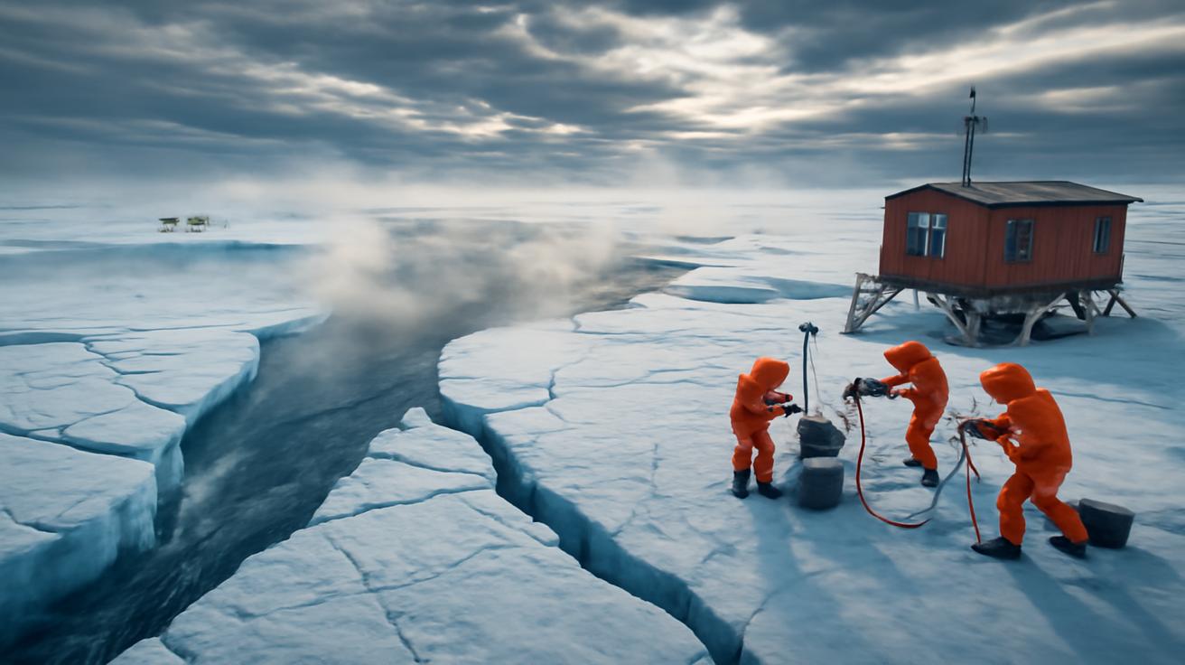
Getting the robot under the ice shelf required another feat of engineering. Out on the sea ice, researchers used a hot-water drill to melt a narrow shaft down through hundreds of meters of ice. Steam rose in ghostly plumes as the drill melted the glacier from the inside, carving a tunnel barely wide enough for the robot. Then, with a shiver of tension, they lowered the machine into the black water below.
There was a moment, as the cable went slack and the robot’s thrusters flickered to life, when everyone on the surface held their breath. After that, the glacier swallowed it.
The Eight-Month Drift
Beneath the ice shelf, the ocean is not still. It moves in slow, powerful rivers—warmer water creeping in from the deep, colder water spilling back out, all of it invisible from the world above. The robot’s mission was to map this hidden circulation and, more importantly, to measure how it was eating away at the ice.
For eight months, the robot traced patterns under the glacier’s belly. It hugged the ice from below, pinging it with sonar, mapping its thickness and shape. It dipped down along the seafloor, searching for valleys and ridges where warm water could funnel in. It crawled into crevices and under overhangs, carefully measuring the temperature and saltiness of the water around it, listening to the quiet hiss and crackle of melting ice.
It drifted with tides and currents, sometimes cruising, sometimes hovering almost motionless, waiting out periods of bad navigation. Where the ice was rough, it mapped gigantic staircases and arches, like frozen cathedrals in the dark. In some places it found “basal channels”—tunnels carved upside down in the glacier’s underbelly where relatively warm ocean water had gnawed a path, like rivers flowing along the ceiling of a cave.
Every so often, when it found a pocket of loose sea ice or disturbed sediment, its thrusters kicked up a faint blizzard and dusted the sensors. Then it would pause, recalibrate, and press on.
Above it, the glacier groaned. Cracks opened and closed. Huge slabs shifted millimeters at a time, transferring the weight of entire mountain ranges of ice out toward the sea. None of that motion was visible to the robot—just quiet pressure, a subtle change in the distance between the ice below and the ice above, a whisper of vertical movement in the data.
Slowly, the robot stitched together a portrait of a world in motion. When it finally came back, riding a narrow corridor of water out from under the shelf to the surface, it carried a hard drive full of that portrait—and, buried inside the raw readings, the signal scientists were scared to find.
The Fear in the Numbers
In a small lab far from the ice, the data looked almost ordinary at first: long columns of numbers, waveforms, color-coded profiles of temperature and salinity. Not dramatic, not cinematic. Just lines on a screen.
Then patterns began to appear.
First was the water itself. The robot had confirmed that warm, salty water—known as Circumpolar Deep Water—was not just reaching the base of the glacier. It was lingering there, pooling in troughs and channels, spreading out along the seafloor and then lifting upward to lick at the ice. In some places, the temperature of this water was only a couple of degrees above freezing. To humans, that sounds harmless. To ice, that’s like being slowly bathed in acid.
The second signal lay in the shape of the glacier’s underside. The robot’s sonar found that portions of the ice shelf base were not smooth and gently sloping, as older models had assumed. Instead, they were jagged, scalloped, and undercut. Imagine the overhang of a roof with the walls below quietly eroding away—only here the “roof” is a kilometer-thick river of ancient ice, and the “house” is the continent’s ability to hold that ice back from the ocean.
Most troubling was what the scientists saw when they combined those maps with melt-rate measurements. The robot’s sensors showed that in key areas—especially near grounding lines, where the glacier lifts off the bedrock and begins to float—the ice was thinning faster than predicted. In places, melting was focused into deep channels rather than spread evenly, like a knife cutting into the belly of the glacier instead of a blanket slowly wearing it down.
This is the signal they had long feared: evidence that the glacier’s retreat may already be slipping into a more unstable phase.
For years, models have suggested that once certain Antarctic glaciers pass a tipping point, a process called marine ice sheet instability could take over. If the bedrock under the ice slopes downward as you go inland, then as the glacier retreats, it floats over deeper and deeper water. That makes the ice more prone to melting from below, which makes it retreat even faster—a feedback loop that’s hard to stop once it starts.
The robot’s data showed precisely the kind of geometry and melt patterns that could set that loop in motion: warm water reaching deep inland, undercutting grounded ice, carving channels along the point where the glacier meets the sea.
On screen, it was just an accelerating curve, a cluster of bright colors, a map shaded a little too red for comfort. In the room, it felt like a door had quietly clicked open, somewhere deep under the ice.
Why One Glacier Matters to Every Coastline
It might feel hard to care about the hidden underside of a glacier you will never see. The ice is far away. The ocean below it is even farther. But what happens there is already rippling outward toward places where children play on sandy beaches and commuters bike past low riverbanks on their way to work.
Antarctica’s ice sheets hold enough frozen water to raise global sea levels by dozens of meters if they were to melt entirely. No one expects that to happen overnight. But parts of West Antarctica—especially glaciers like Thwaites and its neighbors—sit on bedrock that dips inland, forming the perfect setting for runaway retreat.
These glaciers act like a giant plug or buttress against the rest of the ice sheet. If they weaken, the ice behind them can flow more quickly into the sea. Picture a line of books on a shelf: remove the heavy book at one end, and the others start to slide.
Scientists estimate that the collapse of Thwaites and surrounding glaciers could eventually add more than a meter to global sea levels. Combine that with melt from Greenland and other ice, and the numbers begin to eat into the edges of our maps.
Here is where the distant robot’s measurements become deeply personal. A few centimeters of sea-level rise can turn a “once-in-a-century” coastal flood into a once-in-a-decade event. A meter or more reshapes coastlines entirely.
| Rise in Global Sea Level | Typical Local Impact |
|---|---|
| +10 cm | Noticeably more frequent “nuisance” flooding in low-lying cities. |
| +30 cm | Severe coastal storms reach farther inland; some coastal wetlands drown. |
| +50 cm | Salty water intrudes into rivers and aquifers; protective infrastructure strained. |
| +100 cm | Permanent loss of some beaches and neighborhoods; large-scale relocation in vulnerable regions. |
Coastal megacities, low-lying island nations, delta farms that grow rice for millions—these places are the eventual downstream recipients of every extra cubic meter of meltwater slipping under an Antarctic ice shelf.
The robot’s data doesn’t say that a meter of sea-level rise is inevitable, or that it will happen on any specific date. What it does say, in the plain language of physics, is that one of the key gatekeepers of that future is eroding from below faster than we thought.
Listening to an Unseen World
There’s something humbling about the way this signal arrived. No dramatic calving of a skyscraper of ice caught on camera. No single spectacular collapse. Just a quiet accumulation of evidence in a place we can’t go, gathered by a patient machine drifting in the dark.
For most of human history, glaciers were looming, immovable things. Early polar explorers treated them as walls or obstacles. Even in the age of satellites, we mostly saw them from above: bright white sheets, slowly shrinking at the edges.
Now, increasingly, the story is being told from below.
Autonomous vehicles like this one are changing how we understand polar ice. They reveal the under-ice caves and river systems, the hidden canyons where warm water creeps in, the fabric of the seafloor that shapes how glaciers rest and how they slip. Their maps feed into new models that let scientists test different futures: What if the ocean warms by another degree? What if winds change, pushing more deep water onto the continental shelf?
In that sense, the robot is not just a messenger of bad news. It’s also a guide, helping us see where our choices matter most. The rate at which we add greenhouse gases to the atmosphere determines how much extra heat the oceans must absorb—and how aggressively they will attack ice from below. Better data makes those futures less like guesswork and more like a set of constrained, navigable paths.
There’s another, quieter gift in this sort of exploration: a renewed sense of wonder. Beneath a sheet of ancient ice, in total darkness, there is a dynamic, delicately balanced world we barely knew existed a generation ago. There are microbial communities clinging to the underside of ice, sediments whispering stories of earlier glacial retreats, channels carved by unseen currents.
The robot’s journey reminds us that the planet is both more intricate and more vulnerable than we often imagine.
Between Dread and Resolve
When the scientists finished their first pass through the data, the room was not full of panic. It was quieter than that. A few people went back to old notebooks, double-checking calculations. Others turned to whiteboards, sketching new diagrams of the glacier’s base, thinking through how to fold this information into the broader puzzle of ice-sheet behavior.
They knew what the signal meant. It meant that parts of the Antarctic ice system are entering a phase where small changes can trigger large consequences. It meant less time to adapt, less margin for error. It meant that old comforting assumptions—that melting would be slow, that changes would unfold neatly over centuries—were wearing thin.
But dread was not the only emotion in the room. There was also a kind of steely resolve. Knowing is different from guessing. Uncomfortable knowledge can still be used.
The robot’s eight-month drift beneath the ice is already influencing how coastal planners think about risk, how international climate negotiators talk about long-term targets, how engineers design sea walls, how communities consider when and where to build—or not build—homes.
It does not tell us to give up; it tells us where the urgency truly lies.
There are choices humans can still make that matter profoundly to the future of these glaciers. The more we limit warming now, the more we slow the expansion of warm water gnawing at their roots. The better we understand their hidden geometry, the more accurately we can plan for the seas we will live beside in fifty or a hundred years.
And in a more philosophical sense, the robot’s voyage under the ice offers a mirror. It shows a species willing to send fragile tools into hostile darkness just to better grasp the consequences of its own actions. That is a sobering kind of courage—and a fragile kind of hope.
What the Glacier Is Saying
Back on the ice, the hole the scientists drilled has long since refrozen. Winds scream across the surface, erasing the tracks of sleds and snowmobiles. The glacier flows on, slow and implacable, as it has for tens of thousands of years.
No one standing there could guess that, far below their boots, the ocean is reaching farther under the ice than it used to. No one could hear the subtle shift in the creaks and groans as warm water hollows out new paths. The glacier does not send us a warning siren. It only alters its balance, one meltwater channel at a time.
The robot, though, has given that silence a faint, quantifiable voice. In its careful measurements is a simple message: the ice is not as secure as we imagined. The buttresses are thinner. The hidden doors are opening.
What we do with that message—how we respond to this quiet alarm from beneath Antarctica’s massive glaciers—will help define the coastlines that ring the lives of billions of people. We can choose to treat it as distant news from a faraway wilderness, or as an intimate dispatch from one of Earth’s most important guardians of the sea.
Somewhere in a warehouse or lab, the robot itself is likely being examined now, its hull scratched from brushes with ice, its sensors recalibrated, its batteries replaced. Its data has already traveled around the world. Its story, though, is still just beginning to sink in.
In the years ahead, more machines will follow. They will drift farther, dive deeper, map more of the unseen edges where ice meets ocean. Together, they’ll help us read what the glaciers are telling us in the only language they have: the slow, relentless choreography of water and ice.
We feared this signal, and now we have heard it. The question that lingers, unsettling and alive, is whether we will let it guide us in time.
Frequently Asked Questions
What exactly did the robot detect beneath the glacier?
The robot measured warmer, saltier ocean water reaching deep under the glacier, along with unexpectedly rapid melting and undercutting at its base—especially near the grounding line where the ice begins to float. Together, these signals suggest the glacier may be entering a more unstable phase of retreat.
Why is warm water under the ice shelf such a big problem?
Even water that is only slightly above freezing can melt ice efficiently when it stays in contact with it. Under Antarctic glaciers, this warm water can carve channels and undercut the ice from below, thinning the glacier and making it easier for large sections to break away and flow into the ocean.
Does this mean sea levels will rise suddenly?
Sea-level rise from Antarctic glaciers is still expected to unfold over decades to centuries, not overnight. However, the robot’s data suggests that the pace of change could be faster than some earlier estimates, reducing the time available for adaptation and increasing the risk of more rapid sea-level rise later this century and beyond.
Can anything be done to slow this process?
Yes. The main driver of ocean warming is global climate change caused by greenhouse gas emissions. Reducing those emissions limits how much extra heat the oceans must absorb, which in turn influences how aggressively they melt glaciers from below. Better data also helps governments and communities plan more wisely for future coastal changes.
Why do scientists need robots for this kind of research?
The space beneath Antarctica’s ice shelves is inaccessible to humans—too deep, too cold, and completely sealed by thick ice. Robots like autonomous underwater vehicles can navigate in darkness without GPS, withstand high pressures, and map the glacier’s underside with sonar and sensors. They are our only practical way to explore and monitor these hidden, critical regions.


Leave a Comment